www.livescience.com
Peculiar land bridge separates a pair of colorful lakes in Patagonia — Earth from space
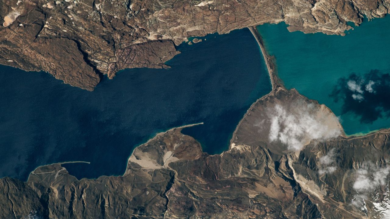
QUICK FACTSWhere is it? Lake Pueyrredón and Lake Posadas, Argentina [-47.41961002, -71.87622200]What's in the photo? The point where two different-colored lakes meetWho took the photo? An unnamed astronaut on board the International Space StationWhen was it taken? Sept. 15, 2020This eye-catching astronaut photo shows the point where an ancient Patagonian lake has been split by a peculiar land bridge, creating two contrastingly colored bodies of water.Lake Pueyrredón (on the left in the photo) is the Argentine half of a roughly 40-mile-long (65 kilometers) glacial lake, which stretches across the country's border with Chile in Patagonia — a region in South America that is well known for its diverse range of geographic features, including mountains, fjords, deserts and rainforests. The Chilean half of the lake is known as Lake Cochrane (not shown in this image). Both halves hold crystal-clear water that is up to 1,600 feet (500 meters) deep, giving Pueyrredón a deep blue hue when viewed from above. Thousands of years ago, a thick sediment barrier formed across the southern section of Lake Pueyrredón, creating a new body of water known as Lake Posadas. This smaller body, which is roughly 5 miles (8 km) long, has a lighter, teal color due to its shallow water and a large influx of sediment from a nearby river, according to NASA's Earth Observatory. Other rivers from nearby hills have previously dumped large quantities of sediment along the western shore of Lake Pueyrredón (bottom of the photo), creating a trio of fan-shaped landforms, known as deltas, that increase in size from north to south (left to right in the photo).Wind-driven currents and waves have pushed some of this sediment from the outer edges of the two smaller deltas, creating long, thin strips of land, known as sandspits, pointing down-current.This image, snapped from the banks of Lake Posadas, shows a close-up view of the rocky barrier that formed across Lake Pueyrredón thousands of years ago. (Image credit: Prisma Bildagentur/Universal Images Group via Getty Images)The strip of land separating Pueyrredón and Posadas looks similar to the sandspits. However, it is most likely a moraine — a barrier of sediment and larger rocks that formed along the edge of a hefty iceberg or long-lost glacier, according to the Earth Observatory.Eagle-eyed viewers may be able to spot a narrow airstrip on the smallest delta (running almost parallel with its sandspit). While the area is largely uninhabited, it is popular with tourists, who travel to the lakes to camp, hike, fish and kayak, according to a local travel site. Lake Posadas is also home to a unique island with a massive rocky arch (see below) that is also popular with tourists. This photo, captured in the side-view mirror of a tourist's car, shows the famous rocky arch in Lake Posadas. (Image credit: alextorrenegra via Wikimedia)The two lakes in the astronaut photo sit within a large valley, which was carved by a massive ice sheet that once covered the area. The last remnants of this ice sheet are located in northern Patagonia, around 20 miles (30 km) west of Lake Cochrane, and have also been snapped from space by astronauts. Patagonia is home to dozens of similar valleys and fjords that were carved out by the same massive ice slab. Around 210 miles (340 km) southwest of Pueyrredón and Posadas, a trio of ravines converge to create a rare configuration where a lake, river and glacier "touch" each other at a single point. See more Earth from spaceMini lake meets massive glacierA 2010 satellite photo shows the point where a small lake bisects the snowy rim of an ancient glacier on Canada's Baffin Island. The rippling, snow-rimmed structure is the last remaining fragment of a colossal ice sheet that once covered large parts of North America.Trio of 'battleground' glaciers mergeThis 2023 astronaut photo shows three glaciers merging into a single massive ice mass in the Karakoram mountains. The stripy glaciers have gained ice in recent decades, despite the effects of human-caused climate change.World's highest frozen lake shattersA 2024 astronaut photo shows the icy surface of Pangong Lake breaking apart in the lofty Tibetan Plateau. The point where the ice meets the water almost perfectly matches a disputed border between China and India.








 New Posts (Home)
 ChatBox
 Popular Posts
  Game Zone
 Top PodCasts