allthatsinteresting.com
Inside The Battle Of Berlin And Its Catastrophic Death Toll
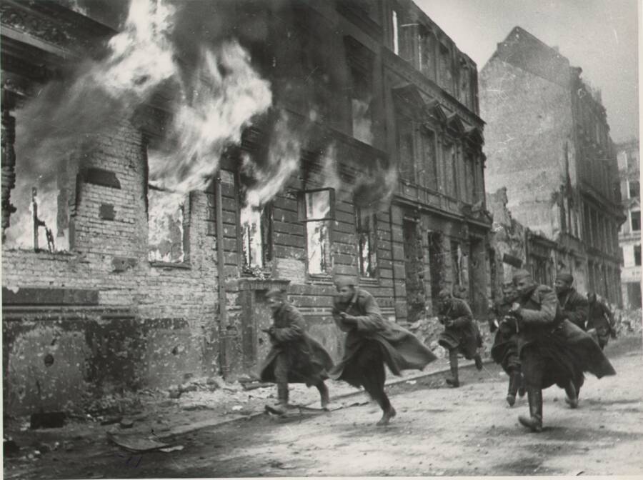
Ministry of Defence of the Russian FederationRed Army troops storming Berlin on April 30, 1945.
On April 16, 1945, millions of Soviet troops reached the outskirts of Berlin. They’d been plotting their final attack on the city for months, and the Battle of Berlin was about to begin.
Over the next two weeks, the Red Army relentlessly shelled the capital of the Third Reich. Once they breached the city’s borders, the conflict turned even bloodier. By May 2, an estimated 100,000 German troops and 80,000 Soviets were dead. But the civilians of Berlin suffered the highest death toll: 125,000 men, women, and children were killed over the course of the battle.
By the time the smoke cleared, Adolf Hitler had died by suicide, Germany had surrendered, and the Third Reich had collapsed. The Battle of Berlin was one of the final battles on the Eastern Front of World War II, securing an Allied victory in Europe.
However, the fall of Berlin and Hitler’s regime also set the stage for the next global conflict: the Cold War.
The Soviet Union In World War II
World War II officially began on Sept. 1, 1939, with Nazi Germany’s invasion of Poland. Days earlier, Germany and the Soviet Union had signed a non-aggression pact that effectively divided Eastern Europe between the two nations.
German Federal ArchivesAdolf Hitler watches as German troops march into Poland. September 1939.
While the Soviets occupied eastern Poland, Germany took over the western half of the country. The U.S.S.R. also annexed Estonia, Latvia, and Lithuania, as well as parts of Finland, Romania, and Czechoslovakia. Meanwhile, the Nazis occupied vast swaths of Europe, including Denmark, the Netherlands, Belgium, France, Norway, and Yugoslavia.
Then, Adolf Hitler made plans to seize the Soviet Union, too. The pact between Germany and the U.S.S.R. came to a violent end on June 22, 1941, when the Nazis launched Operation Barbarossa and invaded Soviet territory.
The operation wasn’t as successful as Hitler had hoped. Germany’s invasion led to the bloodiest battle of the war, the six-month-long Battle of Stalingrad, which saw upwards of four million casualties, including at least one million fatalities.
Public DomainSoviet troops run through trenches during the Battle of Stalingrad. December 1942.
With the disintegration of the pact, the Soviet Union switched allegiances, joining the Allied Powers for the remainder of the war. However, Joseph Stalin didn’t fully trust the other Allies. He wanted to capture Berlin for himself, both to seek revenge for Operation Barbarossa and ensure that the U.S.S.R. walked away from the war with a greater sphere of influence in Europe.
So, in early 1945, Soviet forces began advancing toward Berlin — and by mid-April, they were ready to attack.
Inside The Blood-Soaked Battle Of Berlin
By the spring of 1945, much of Berlin was already in ruins from previous Allied bombing campaigns. The city was no longer protected by a robust army. Indeed, most German soldiers who hadn’t been killed, wounded, or captured were stationed along the Western Front. Instead, Berlin was largely defended by unorganized and ill-equipped militias. They were aided by the Hitler Youth, with one battalion having an average age of just 14.
German Federal ArchivesMembers of Germany’s Volkssturm — the “People’s Militia” that helped defend Berlin — holding anti-tank weapons in preparation for the upcoming battle. March 1945.
In contrast, the Soviet forces were heavily armed. With nearly 2.5 million troops, 7,500 aircraft, and 6,250 tanks, the Red Army was ready to fight to the end, regardless of the cost.
Early in 1945, the Soviets were held off roughly 60 miles east of Berlin, but they fought their way forward, reaching the city’s suburbs around April 16. After a three-day standoff at Seelow Heights, the Battle of Berlin began in earnest.
Soviet forces launched as many as two million shells into the city, destroying countless buildings and killing thousands of German troops and civilians alike. Once they entered Berlin proper, soldiers went from house to house searching for enemies. They reportedly lobbed grenades into cellars in hopes of clearing out concealed snipers — with no regard for who else may be sheltering inside.
German Federal ArchivesThe Brandenburg Gate stands above the ruins of Berlin. June 1945.
The Germans desperately fought back. The city’s layout gave them some advantage against the Soviets, slowing down the Red Army tanks so the Hitler Youth could ambush them with Panzerfaust anti-tank rockets.
Armed with only a machine gun, three lone German soldiers were able to hold off Soviet forces on a bridge for two days. However, the pure firepower of the Red Army ultimately overpowered the fragmented German troops.
As the city descended into chaos, life became a nightmare for Berliners. Soviet troops raped civilian women, looted and destroyed businesses, and ignored cries for mercy.
“There was no escape,” one survivor, Gerda Drews, later told her daughter-in-law, author Elinor Florence. “I prefer not to talk about what happened when the Russians arrived at our house and discovered us, because it is too painful.”
Some families even resorted to hanging flags of surrender from their windows, risking execution by Nazi firing squads for betraying the regime.
But civilians weren’t the only ones who abandoned the Third Reich during the Battle of Berlin. Many German soldiers tried to flee the city to surrender to British or American troops rather than face capture by the Soviets. Others died by suicide — including Adolf Hitler himself.
Hidden in his Führerbunker during the onslaught, Hitler initially denied the reality of what was happening outside. But on April 30, he realized that Germany didn’t stand a chance and took his own life alongside his new wife, Eva Braun. In a final bout of propaganda beyond the grave, Nazi officials reported that Hitler had fallen in battle.
Ministry of Defence of the Russian FederationRed Army troops raise a Soviet flag over the Reichstag government building in Berlin on May 2, 1945.
After the news of Hitler’s death broke, the Battle of Berlin — and the war in Europe — came to a swift end. The Soviets had captured the city by May 2, 1945, and Germany officially surrendered on May 7.
But while the Battle of Berlin was the final major battle on the Eastern Front of World War II, the struggle for power in Germany was just beginning.
The Enduring Aftermath Of The Battle Of Berlin
After the war, Berlin was split into four quadrants that were each controlled by a different power: Great Britain, France, the United States, and the Soviet Union. However, conflict almost immediately broke out between the U.S.S.R. and the other three nations.
Public DomainSoviet and British troops climb the remnants of the Reich Chancellery following the Battle of Berlin. July 1945.
The Soviets wanted reparations — even though the reparations Germany paid after World War I were a major factor in the rise of Hitler and the outbreak of World War II. Tensions escalated throughout the 1940s, and in a 1946 speech, Winston Churchill famously declared that “an iron curtain has descended across the Continent.”
Two years later, the Soviets officially established East Berlin, and the Berlin Wall was constructed in 1961. It separated the city for nearly three decades until its fall in 1989 as a concrete symbol of the Cold War between the Soviet Union and the Western world.
As such, the Battle of Berlin didn’t just mark the end of World War II in Europe. It was a harbinger of the next struggle on the horizon and the arms race that would grip the world for the decades to come.
After reading about the Battle of Berlin and its impact on world history, go inside the Blitz, Nazi Germany’s bombing campaign against Great Britain. Then, learn about the final performance of the Berlin Philharmonic as the Red Army approached the city.
The post Inside The Battle Of Berlin And Its Catastrophic Death Toll appeared first on All That's Interesting.