ridermagazine.com
Above the Timberline—Riding Canada’s Wild Rocky Mountain Corridor
Stretching through Alberta and British Columbia, the Calgary-Banff-Jasper riding region delivers one of the most visually concentrated mountain experiences in North America. This isn’t a single highway or signature pass, it’s a connected system of alpine roads, glacier corridors, turquoise lakes, and wildlife-filled valleys that reward riders who slow down and absorb the surroundings.
At the heart of it all is a simple but world-class progression: Calgary as the launch point, Banff as the gateway, the Icefields Parkway as the centerpiece, and Jasper as the remote northern anchor. Together, they form a motorcycle loop that feels like continuous transition through geological time.
Start in Calgary
The ride begins in Calgary, where prairie flatlands quickly give way to rolling foothills. Within an hour, the horizon starts to change shape. The first real shift comes as you approach Banff National Park, where the land begins to rise, compress, and sharpen. Mountains appear suddenly, and the road responds by tightening into flowing curves that guide riders into the heart of the Rockies.
Banff acts as both an introduction and pressure release valve. It’s a mountain town with full infrastructure but also immediate access to serious riding. From here, riders can sample short loops into Tunnel Mountain, Lake Minnewanka, or Lake Louise, or simply use Banff as a staging point before committing to the longer northbound stretch.
That stretch—the Icefields Parkway (Highway 93)—is the defining segment of the entire region.
Icefields Parkway
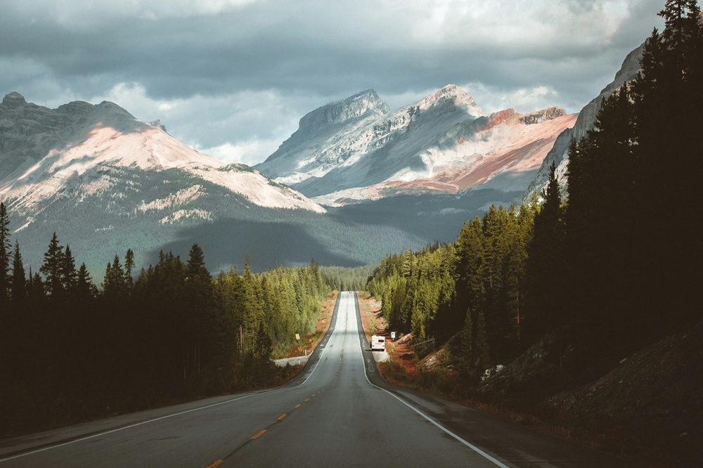
Running roughly 140 miles between Lake Louise and Jasper, the Icefields Parkway is one of the most consistently scenic mountain roads in the world. It doesn’t rely on a single highlight. Instead, it stacks them: Bow Lake, Peyto Lake, Sunwapta Falls, Athabasca Glacier, and endless unnamed valleys where waterfalls drop directly from hanging glaciers into river systems below.
For motorcyclists, the Parkway is a rhythm ride. Long sweepers connect massive viewpoints. Traffic exists but rarely dominates. Wildlife is constant—elk, mountain goats, and bears are not unusual sightings. Elevation changes are steady but not extreme, creating a ride that feels fluid rather than technical.
Halfway along the route, the Columbia Icefield area introduces one of the most dramatic geological features in North America. Massive ice sheets sit just above the roadway, feeding meltwater systems that define the entire region. It’s also where weather begins to feel more volatile—sunlight, wind, and cold can rotate quickly in the same hour.
As the Parkway continues north, the landscape subtly shifts again. The mountains open. Valleys widen. The sense of enclosure fades. By the time riders reach Jasper National Park, the environment feels less vertical and more expansive, with long river valleys and open alpine basins replacing the tighter geometry of Banff’s southern ranges.
Jasper National Park
Jasper itself serves as the northern anchor of the riding system. It’s quieter than Banff, less compressed, and more spread out in its riding opportunities. Routes into Maligne Lake, Medicine Lake, and surrounding wilderness corridors create loop options that reward exploration rather than point-to-point travel.
Few places in the world allow riders to move through glaciers, forests, river valleys, and alpine ridges in a single uninterrupted sequence without ever leaving a connected road network. Even fewer do it with this level of accessibility and infrastructure support.
Weather plays a major role in shaping the experience. Even in summer, conditions can swing quickly between warm valley riding and cold, wind-exposed passes. Afternoon storms are common. Elevation changes affect temperature more than distance does. Riders quickly learn that preparation here is not optional.
But when conditions align, the Canadian Rockies deliver something rare: a riding experience that feels cinematic. There are no manufactured overlooks or curated experiences. Just roads placed directly into a landscape that was already overwhelming before the pavement arrived.
Travel Resources
At a Glance
Location: Calgary → Banff → Icefields Parkway → Jasper (Alberta, Canada)Distance: ~250miRide Time: 2-5 daysBest Direction to Ride: South to north (Calgary → Jasper) for gradual escalation of scenerySkill Level: Intermediate (mountain riding + wildlife awareness)Best Bike Type: ADV, sport-touring, touring
Maps & Routes
<iframe src="https://www.google.com/maps/d/embed?mid=17m_4DurjZJhWjcjPtTXeNT75RKxmsP8&ehbc=2E312F&noprof=1" width="640" height="480"></iframe>
Click to view the route on REVERClick here to download the GPS files
Road Conditions
Roads throughout the Canadian Rockies riding corridor are generally excellent in surface quality, but conditions vary with elevation, weather, and traffic volume. The Icefields Parkway is fully paved and well-maintained, featuring long sweeping curves, steady elevation changes, and frequent pullouts for scenic stops. Traffic can be heavy during peak summer months, especially near Banff and Lake Louise. Wildlife crossings are common throughout all segments, particularly in early morning and evening hours. Weather is the most variable factor—sun, rain, fog, and even snow can occur in a single day at higher elevations. Riders should expect reduced temperatures in mountain corridors, even when valley floors are warm.
Best Time to Travel
The prime riding season in the Canadian Rockies runs from late June through September, when mountain passes are fully open and weather is most stable. July and August offer the warmest temperatures and clearest access but also the highest tourist traffic, especially around Banff and Lake Louise.
Early summer provides quieter roads and active waterfalls from snowmelt, while early fall introduces cooler air and fewer crowds. Outside of summer months, sections of the Icefields Parkway and high-elevation routes may experience snow, closures, or unpredictable conditions. Riders should prepare for rapid weather changes regardless of season, with layered gear and cold-weather protection recommended even in peak summer.
Road Food
Food along the Calgary-Banff-Jasper corridor is heavily influenced by tourism and mountain culture. Calgary offers full urban dining options, while Banff and Jasper feature a mix of casual restaurants, pubs, cafes, and lodge-based dining. Expect hearty meals designed for active travelers—breakfast-heavy menus, grilled meats, soups, and comfort food staples.
Along the Icefields Parkway itself, food options are extremely limited, so riders should plan meals in advance and rely on Banff, Lake Louise, or Jasper as primary food hubs. Coffee stops and quick-service restaurants are common in town centers, but remote sections of the ride require self-sufficiency. Hydration and snacks are strongly recommended for full-day Parkway rides.
Nearby Lodging
Lodging is widely available in Calgary, Banff, and Jasper, with Banff and Jasper serving as the primary riding bases for exploring the region. Options range from hotels and motels to cabins, lodges, and backcountry camping. Banff offers the most infrastructure and convenience, while Jasper provides a quieter, more remote feel.
Along the Icefields Parkway itself, lodging is limited to select lodges and campgrounds, often requiring advance reservations due to high demand. Many riders choose a two-base strategy—staying in Banff and Jasper and using the Parkway as a daily ride rather than an overnight route. Motorcycle-friendly accommodations are common, with ample parking and easy access to fuel and services in town centers.
Points of Interest
Banff National Park gateway and town core
Lake Louise and Moraine Lake access region
Bow Lake and Peyto Lake viewpoints
Icefields Parkway glacier corridor
Columbia Icefield and Athabasca Glacier
Sunwapta Falls and surrounding canyon systems
Jasper National Park wildlife valleys
Maligne Lake and Medicine Lake routes
Athabasca River valley riding sections
If You Have More Time
The Canadian Rockies integrate easily into larger Western Canada riding routes. South of Banff, riders can extend into Kananaskis Country for quieter, more technical mountain roads. Eastward, the prairies offer long-distance touring across Alberta’s open landscapes.
West of Jasper, Highway 16 (the Yellowhead Highway) provides a continuation into British Columbia’s interior riding regions. Many riders also combine this loop with multi-park itineraries that include Yoho, Kootenay, and Glacier National Park in Montana for a broader cross-border Rockies experience. The strength of this region is flexibility—riders can build anything from a short three-day highlight loop to a multi-week alpine tour without ever leaving mountain terrain.
The post Above the Timberline—Riding Canada’s Wild Rocky Mountain Corridor appeared first on Rider Magazine.








 New Posts (Home)
 ChatBox
 Popular Posts
  Game Zone
 Top PodCasts