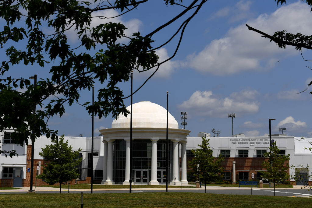
YubNub Social YubNub Social
    #satire #libtards #liberals #antifa #blm
    Advanced Search
  • Login
  • Register

  • Day mode
  • © 2025 YubNub Social
    About • Directory • Contact Us • Developers • Privacy Policy • Terms of Use • shareasale • FB Webview Detected • Android • Apple iOS • Get Our App

    Select Language

  • English
Install our *FREE* WEB APP! (PWA)
Night mode toggle
Community
New Posts (Home) ChatBox Popular Posts Reels Game Zone Top PodCasts
Explore
Explore
© 2025 YubNub Social
  • English
About • Directory • Contact Us • Developers • Privacy Policy • Terms of Use • shareasale • FB Webview Detected • Android • Apple iOS • Get Our App
Advertisement
Stop Seeing These Ads

Discover posts

Posts

Users

Pages

Blog

Market

Events

Games

Forum

Conservative Voices
Conservative Voices
1 y ·Youtube Politics

YouTube
What's the Truth About Illegals Voting?
Like
Comment
Share
Conservative Voices
Conservative Voices
1 y

Watch: Parkinson's Expert Drops Bomb on Biden Live on Air, Shuts Down NBC Host Trying to Downplay Decline
Favicon 
www.westernjournal.com

Watch: Parkinson's Expert Drops Bomb on Biden Live on Air, Shuts Down NBC Host Trying to Downplay Decline

If optics went from bad to worse for President Joe Biden during June 27's presidential debate, on Monday they went from worse to absolutely catastrophic. Ever since the infamous debate, which a mentally hampered Biden pathetically mumbled his way through, Democrats and their donors have become increasingly loud in their...
Like
Comment
Share
Conservative Voices
Conservative Voices
1 y ·Youtube Politics

YouTube
THIS is bedside manners?!
Like
Comment
Share
Bikers Den
Bikers Den
1 y

Enchanted Kingdom: Northeast Vermont Motorcycle Ride
Favicon 
ridermagazine.com

Enchanted Kingdom: Northeast Vermont Motorcycle Ride

Vermont’s unmaintained Class IV roads offer access to truly off-the-beaten-path scenery and long-forgotten historic sites as well as enchanting along this Vermont motorcycle ride. Photos by Susan Dragoo. It’s all scenic. It’s all charming. And it’s all green … except when it’s not, and then it’s even better. A few days into a trip to the lush forests of northeastern Vermont, we were reminded of Sedona, Arizona. The connection between these two dramatically different climes may at first seem nebulous, but Vermont’s consistent beauty called to mind the time we visited an outdoors outfitter in Sedona and asked, “Which are the most scenic trails?” The jaded clerk responded with a sigh, “All of them. They’re all scenic.” His tone let us know there was nothing to be gained by pressing him for further details. We would have to make our own choices from the seemingly infinite good ones available. Burke Mountain’s ski lift sits idle in the summer, when the resort is popular with mountain bikers riding the nearby Kingdom Trails Network. Likewise, trying to narrow down the best scenery in Vermont is a fool’s errand. It would be difficult to make a bad choice. Our adventure riding journey to the state’s Northeast Kingdom took us into what may be some of Vermont’s most remote territory, lending itself beautifully to the pursuit of riding motorcycles down dark, green, tree‑­canopied lanes and over roads the likes of which Paul Revere might have traveled in colonial days. See all of Rider‘s Northeast U.S. motorcycle rides here. Willoughby Gap is Burke Mountain’s most iconic view. These are Vermont’s northeastern highlands, dubbed the Northeast Kingdom in the 1940s by a former Vermont governor in recognition of the area’s distinct culture and geography. The region lies within the southernmost range of the cold boreal forest of spruce and fir, birch and aspen, which stretches to the Arctic. It’s a place of long winters and short growing seasons where ponds, lakes, and villages nestle in valleys and twisting roads follow clear streams between small granite hills and mountains. Adventure in Vermont, like the New England states themselves, comes in tight and tidy packages, so the remoteness here can be surprising to the traveler accustomed to the vast, open American West. Remnants of a 1930s Civilian Conservation Corps camp at the summit of Burke Mountain. It was mid‑­September, on the cusp of the imminent explosion of fall colors for which this place is famous. Still, there was plenty of sensory stimulation. Besides the inexplicable feeling of navigating these woods in a late summer shower, leaves were beginning to carpet the trail like gold doubloons cast forth from some cosmic seeder. Pungent scents of cut evergreens, vegetation at the end of its cycle, and earth, freshly disturbed by our tires and dampened by the rain, filled our heads with aromas fit for expensive candles sold in artisan shops. Days that started with fog and mist and ended with afternoon showers added mystique and urgency to move along yet held us in the moment, hoping it would never stop. Riding in the Northeast Kingdom is an experience of lush, green forests and nearly infinite backroads. Eric Milano, owner of MotoVermont (see sidebar below), led our group of a dozen riders from all walks of life. Most were successful in business and seeking another way to enjoy the outdoors. Sailors, skydivers, scuba divers, and racecar drivers, they were here to learn the nuances of adventure riding versus railing through the woods with their hair on fire, replaying the antics of their younger selves. An adventure bike is the perfect vehicle for enjoying it, and MotoVermont organizes great tours to get the most out the area. Our business, D.A.R.T. (Dragoo Adventure Rider Training), is often invited on such tours to coach guests not only on the finer points of riding well over difficult terrain but also the philosophy of leaving behind a legacy of responsibility as we explore on adventure motorcycles, a term that can apply to most any off‑­road‑­capable two‑­wheeled machine with enough legs to make it between fuel stops. Descending a rocky ledge lends the perfect opportunity for a little fun. A high priority for adventure riders is respecting landowners and other trail users, helping to ensure trails stay open. There is more than enough joy in smelling the roses (and other flora) while tackling technical trails with natural obstacles. Adventure riders see no need to run loud pipes, ride at breakneck speeds, or travel off trail, risking damage to adjacent lands and hard‑­earned relationships. Respectful behavior on roads and trails helps to ensure continued access. Our first day together was dedicated to enhancing rider skills, and the second was spent applying them over some of Vermont’s most remote backroads. Many are Class IV roads, barely maintained byways kept open mostly by locals who traverse their craggy, narrow tunnels on snow machines during winter and by motorcycle the rest of the year. The mountains of the Northeast Kingdom offer some of the area’s most iconic scenery. Our troupe traveled west out of Burke Mountain Resort, stopping off at Cafe Lotti in East Burke before turning north and entering the woods and our first Class IV challenge. Cafe Lotti is a homegrown hangout set in a typical aging Vermont building which has no doubt fueled generations of local folk and travelers alike with a belly full of breakfast and a hot cup of craft coffee or tea. It is the perfect meeting spot for adventure seekers of all types, from mountain bikers to adventure riders to cross‑­country and downhill skiers. Whether crossing a burbling stream or stopping for Pure Vermont Maple Syrup, there’s plenty to see along the trail. We left town westbound and turned north into the woods, winding our way past drop lines – pieces of tubing strung between taps in a forest of maple trees like webs from a giant prehistoric and overactive arachnid. Eric stopped at the entrance to a steep, rocky uphill and explained the best options for a successful path of travel. Rain had turned the rocks into slippery entrapments like greased turtle shells, ranging from tiny spotted tortoises to 6‑­foot sea turtles. Most riders made the climb without incident, but one or two forgot their training and sat down or, worse, dragged their feet, losing control and learning the hard way why adventure riders stand up. Steering, suspension, and sight are all improved by standing tall and proud, and this mild lesson was a graphic illustration of just how important it is to do so in the rough. Vermont’s deepest lake, glacial Lake Willoughby, boasts distinctive fjord-like rock formations and is a popular summer attraction. The onset of rough terrain was the portal to this enchanted Northeast Kingdom, a region mentioned in Patricia Schultz’s book 1000 Places to See Before You Die, which boasts that when the foliage flames in autumn, this may well be the most beautiful place in America. Indeed, it should not be missed. A few years back, we made the trip by motorcycle during the peak of fall color, and years ago, Bill traversed Vermont by bicycle on his way across the northern tier of the United States, a solo journey that permanently pinned this place to his psyche and keeps us coming back. Our rugged upward trail eventually turned down, and the trail from the top was no disappointment. Sketchy ruts through mudholes, strategically dispersed to reward good judgment in not rushing, kept us on our toes. Most of these roads shed water well and remained rideable, but caution was of the essence. The road continued to undulate throughout the 100‑­plus‑­mile clockwise loop that would eventually take us back to our starting point. Roadside stands along the way offer a variety of goodies, including fresh eggs. But first, a stop at Devaney Farmstand near the intersection of Hudson Road and Town Highway 29 outside West Charleston, Vermont. The clouds opened and rain came down in full force as we dismounted and climbed a stairway, ducking into a loft room where lunch had been laid out for us by Bob and Sharyl Devaney. Calzones, fresh corn on the cob, and apple pie awaited. We gobbled down the fare as rain drummed on the roof. Maple syrup, candles, fresh jams, and pies of all kinds added their fragrance to the shop, and antiques and other local trinkets were neatly displayed for anyone wanting a souvenir. Our timing was perfect. The sun began to peek through the clouds as we said our thank‑­yous and goodbyes to the Devaneys and fired up our machines. A short ride on twisty pavement led us back to the reason we were here: more Class IV roads. After skirting the fjord‑­like Lake Willoughby, a glacial lake dotted with vacation cabins and summer camps, Eric turned right onto a barely noticeable two‑­track trail that climbed steadily toward the mountain top. It wouldn’t be a trip to Vermont without a covered bridge. The state has 104 historic covered bridges, and many of them are still in use today. Eventually we descended again and crossed an old bridge leading onto a magnificent, fast gravel road following a river through the canyon. Although tempted to open up the throttle, good judgment kept our horses in check, and we ran at a brisk but reasonable pace. Riding right is critical here, as some turns are blind and, as remote as these roads are, we still saw other users. Respectfully, we would hold up five fingers to oncoming traffic if there were five or more riders behind us, then four, three, two, one, and the sweep rider held up a closed fist to indicate he was the last one. Trail etiquette is critical to maintain good relationships with the locals who hold the power to shut us out. We happily demonstrated good stewardship and appreciation for the privilege of exploring their home turf. Riders take a break at Devaney Farms after a filling and delicious lunch. We hit pavement just as the rain began again and made our way the last few miles to the resort. Parking under the canopy, we shed our outer gear and immediately began to relive all that had happened in a short couple of days. New friendships had been made and lessons learned. Everyone left with a quiver full of new skills and a renewed appreciation for our freedom to ride, perhaps not by lantern light warning the colonists of the British invasion, but with our own versions of enthusiasm as we explored the Enchanted Kingdom. See all of Rider‘s touring stories here. SIDEBAR: MotoVermont MotoVermont specializes in adventure motorcycle tours, training, rentals, and retail sales. Tours range from day rides in Vermont to week-long adventures farther afield, including New Mexico, Arizona, North Carolina, and other locations. Training events are typically 1-2 days in length with a focus on balance, mastery of bike controls, preparedness, and courtesy. Rental options include the Yamaha Ténéré 700, Kawasaki KLX 300, and Yamaha XT250. MotoVermont founder and operator Eric Milano is a Backcountry Discovery Routes ambassador and a member of the development team for the NEBDR route. He spends much of his time developing tours and organizing events for adventure motorcyclists. MotoVermont has a retail store in Milton, Vermont, or you can meet them at one of the many rallies and events they attend throughout the Northeast. For more information, visit the MotoVermont website. SIDEBAR: Burke Mountain Resort Burke Mountain Resort offers a comfortable stay with great views of Burke Mountain or Willoughby Gap from every suite. Located three miles from the Kingdom Trails Welcome Center, the resort has 116 suites ranging from studios to three-bedroom suites. Guests can enjoy pub food, craft beers, and cocktails at The View Pub on the second floor, with large windows looking out to Willoughby Gap. Edmund’s Coffee Shop, located in a cozy timber-framed room with stone fireplaces, serves breakfast and coffee. The resort also includes on-site retail shopping opportunities at Bear Essentials and Vertical Drop Retail, with products ranging from basic groceries to home décor and outdoor gear. Other amenities include a heated pool and hot tub, a family arcade, and a fitness center. For more information, visit the Burke Mountain Resort website. Bill and Susan Dragoo own and operate Dragoo Adventure Rider Training (D.A.R.T.) in Norman, Oklahoma, and are widely published writers, especially in the field of adventure travel. Learn more at BillDragoo.com and SusanDragoo.com. The post Enchanted Kingdom: Northeast Vermont Motorcycle Ride appeared first on Rider Magazine.
Like
Comment
Share
Bikers Den
Bikers Den
1 y

Route 66 Motorcycle Ride in Oklahoma | Favorite Ride
Favicon 
ridermagazine.com

Route 66 Motorcycle Ride in Oklahoma | Favorite Ride

The Route 66 Interpretive Center, one of several interesting stops on this Route 66 motorcycle ride, uses audio-visual exhibits to immerse visitors in the history of the Mother Road. The building was built in 1937 and served as an armory until 1971. Photos by the author and Steve Skinner. U.S. Route 66 was established in 1926 and was billed as the shortest, fastest, and most scenic all-weather route connecting Chicago, St. Louis, and Los Angeles. Dubbed the “Mother Road” by John Steinbeck in his novel The Grapes of Wrath, Route 66 was used in the 1930s by migrants fleeing the Dust Bowl in search of a better life out West. During World War II, it facilitated the movement of troops and equipment. And during the post-war economic boom of the 1950s and 1960s, Route 66 became indelibly linked to the Great American Road Trip. Scan QR code above or click here to view the route on REVER My home state of Oklahoma boasts about 400 miles of the historic highway – the most of any of the eight states touched by Route 66. The Mother Road played a central role in my budding love affair with riding. In 1977, at the age of 14, I rode a 100cc 2-stroke Kawasaki along one of the best stretches of Route 66 in the state – the 100 miles between Oklahoma City and Tulsa. The 200-mile round trip was my first long motorcycle journey. It took me all day and cost about $2 in gas, and my long-suffering parents had no idea what I was up to. See all of Rider‘s Southern U.S. motorcycle rides here. Forty-six years after that formative adventure, I retraced my route, only this time I allowed time to take in the roadside attractions and small-town charms that make Route 66 such an iconic piece of Americana. Once again, I felt right at home on the Mother Road.  Not far from my home, I hopped on Route 66 at its junction with Interstate 35 in Edmond. I headed east through wooded terrain and past sprawling Arcadia Lake before stopping at the Arcadia Round Barn. Listed in the National Register of Historic Places, it was built in 1898 by a local farmer who thought its round design would make it tornado-proof. Science may not support that belief, but the Round Barn has survived in the middle of Tornado Alley for 126 years. It’s now a museum, gift shop, and live music venue. The Arcadia Round Barn, built in 1898, was designed to be tornado-proof and still stands in the heart of Tornado Alley. Continuing east, the countryside along this stretch is a mix of woods, farmland, and grazing pasture. Although not the transcontinental artery it once was, Route 66 remains important to the communities it passes through. The tarmac is mostly in great shape, and the occasional sweeping turns are enough to get you off the center of your tires. In Wellston, I stopped at The Butcher BBQ Stand, one of the best barbecue restaurants around. The award-winning flavors were developed during eight years on the competitive barbecue circuit, including more than 400 1st-place finishes. One of my riding buddies calls this barbecue “meat candy,” and he’s not wrong. Thirty minutes before The Butcher opened, the line was already out the door. The Butcher BBQ Stand offers award-winning smoked meats on Route 66 near Wellston. Just a few miles down the road in Warwick is the Seaba Station Motorcycle Museum, which was originally a Route 66 service station named after the proprietor back in the 1920s. The building was purchased in 2007 by Jerry Reis, and he opened the museum in 2010. It’s not only a great place to see a bunch of classic motorcycles, but it also has great Route 66 swag. Seaba Station in Warwick has an impressive collection of vintage bikes and memorabilia as well as a great gift shop for some Mother Road swag. I next headed east-northeast toward the town of Chandler, where roadside attractions include the Route 66 Interpretive Center and Route 66 Bowl, a bowling alley with dozens of authentic vintage oil company signs lining the parking lot. Route 66 Bowl in Chandler with its collection of authentic oil company signs is one of the many Mother Road landmarks to visit on this ride. Another 14 miles up the road, we stopped for lunch in Stroud at the Rock Cafe, another Route 66 institution. Opened in 1939, it’s named after the local sandstone used in its construction, and over the years it has been a trusted stop for long-haul truckers, a high school watering hole, and even a makeshift Greyhound bus station for soldiers shipping out during World War II. Pixar executives made stops at the cafe when developing the hit movie Cars and based the character “Sally Carrera” on proprietor Dawn Welch. The burger I had there was outstanding – and it was cooked on “Betsy,” the original 1939 grill. The iconic Rock Cafe in Stroud gets its name from the sandstone used for its construction in 1939. The delicious food served up there is still cooked on the restaurant’s original 85-year-old grill, “Betsy.” The final stop on my Mother Road reunion tour was Buck Atom’s Cosmic Curios on Route 66 in Tulsa to see “Muffler Man” Buck Atom, Space Cowboy. Few authentic Muffler Men – giant statues used by businesses for eye-catching advertising – remain. Buck Atom was created using a mold from a salvaged 1960s Muffler Man cowboy. Christened in 2019, Buck is 20 feet tall, and he now holds a silver rocket instead of a muffler. He stands guard over a gift shop at the site of an old Route 66 gas station in the heart of Tulsa. The new, old-time Muffler Man fits right in on the Mother Road. A reimagined Muffler Man stands tall at Buck Atom’s Cosmic Curios in Tulsa. Headed back to my home in Oklahoma City with daylight fading fast, I hopped on the interstate to make time – the very interstate that marked the end of Route 66’s prominence in Oklahoma, bypassing many of the communities stitched together by the Mother Road. True, the ride home was faster, but it was far less interesting. Just like during my first highway riding adventure back in 1977, I’m more at home on the Mother Road.  See all of Rider‘s touring stories here. Route 66 Motorcycle Ride Resources Route 66  Travel Route 66 Oklahoma Tourism Oklahoma City Tourism Tulsa Tourism Arcadia Round Barn Seaba Station Motorcycle Museum Route 66 Interpretive Center Rock Cafe Buck Atom’s Cosmic Curios Tim DeGiusti lives and works in Oklahoma City, Oklahoma. Tim returned to motorcycling in 2012 after a long break, and since has ridden throughout Oklahoma and 38 other states (and counting). The post Route 66 Motorcycle Ride in Oklahoma | Favorite Ride appeared first on Rider Magazine.
Like
Comment
Share
Bikers Den
Bikers Den
1 y

Border to Border on the Oregon Backcountry Discovery Route
Favicon 
ridermagazine.com

Border to Border on the Oregon Backcountry Discovery Route

Greg’s BMW taking a dirt nap along the Oregon Backcountry Discovery Route. Photos by Greg Drevenstedt. This story is about a ride that took place in 2013 on the original Oregon Backcountry Discovery Route, which was developed by the Oregon Off-Highway Vehicle Association. The nonprofit Backcountry Discovery Routes organization developed a new ORBDR that was released in 2023. For more information, visit the Backcountry Discovery Routes website. –Ed. Route 5 of the original ORBDR includes hundreds of miles of gravel roads much like this one, plus a decent helping of dirt, sand, rock gardens, and river crossings. When your bike topples over in the middle of nowhere, when your bike and its week’s worth of gear weigh more than 600 lb, when you’re hot and sweaty and tired, it’s good to have friends along to lend a hand. At the California-Oregon border before venturing off-pavement on the ORBDR. We were three days and nearly 300 miles into the 750-mile, California-to-Washington Route 5 of the Oregon Backcountry Discovery Routes (ORBDR), a network of off-road routes crisscrossing the state’s vast national forests. While struggling my way up a technical jeep road full of embedded rocks, I high-centered the BMW’s skid plate, dabbed my left foot into a hole, lost my balance, and toppled over in a big, dusty heap. Lead rider Paul was off in the distance, so sweep rider Marten navigated around me, parked his bike on a level spot, and came back to help. Other than some badge-of-honor scratches on the bike, the only damage was to my pride, and I was soon making forward progress again. Just a few miles into the ORBDR, we took a spur road to the summit of 8,000-foot Crane Mountain, where we enjoyed 360-degree views of California and Oregon. Backcountry Discovery Routes is a nonprofit organization that establishes and preserves off-highway routes for dual-sport and adventure motorcycles. BDR has mapped and documented north-south routes in most states west of the Rockies as well as mid-Atlantic and Northeast routes and shorter BDR-X routes. Inspiration for these routes came from the ORBDR, which, according to BDR’s website, “was created a few decades ago by Bob and Cheryl Greenstreet as a concept to promote managed travel in the backcountry” and is maintained by the Oregon Off-Highway Vehicle Association. The view from Fremont Point on Oregon’s Winter Rim. Paul, Marten, and I wanted to ride the granddaddy of the Backcountry Discovery Routes, so I bought paper maps for Route 5 from OOHVA and Paul spent two weeks creating GPS tracks for us. (GPS tracks are now available upon request when maps are purchased from OOHVA.) Since most of the ORBDR is at 4,000-8,000 feet of elevation, we planned our trip for August to avoid snowpack. A long-time adventure-riding and homebrewing buddy of mine, Paul Beck, is a computer guy. Since he created our tracks and led our group (his GPS was the only one that worked reliably), we dubbed him the Navigator. Marten Walkker, another riding buddy, is a master carpenter. He made his own tailbag, auxiliary gas tank, toolbox, and highway pegs for this trip, so we called him the Fabricator. And since I kept a journal, shot photos, and sent daily postcards to my wife, I became the Chronicler. The Three Amigos at Fremont Point, 3,000 feet above seasonally dry Summer Lake. Similar in pace and temperament and always ready for a quick laugh, we were compatible travelers, like the Three Amigos. We were all of German descent and riding BMWs – Paul on an R 1200 GS, Marten on a G 650 Xchallenge, and me on an F 800 GS Adventure – so Drei Freunde is more accurate, but it doesn’t exactly roll off the tongue. We had to cross the high desert through Christmas Valley to get from the mountains of Fremont National Forest to the mountains of Malheur National Forest. Departing from Ventura on California’s southern coast, our first 750 miles were on pavement as we made our way up to the northeastern corner of the state. A half-mile before the Oregon border on the afternoon of our second day, we turned from U.S. Route 395 onto the unpaved County Road 2 and entered Modoc National Forest as we climbed into the Warner Mountains. We had to shift our brains from the grip and monotony of wide-open pavement to the delicate balance of riding top-heavy adventure bikes on loose, uneven dirt and gravel. The road leveled out within a few miles, and we turned north, passing through the green meadows of the (not so) Dismal Swamp and crossing into Oregon. River crossings are nerve-racking with an audience of forest service workers, but Marten made it through like a pro. After riding a challenging spur road up to the top of 8,000-foot Crane Mountain for panoramic views and navigating through a herd of cows, we stopped at Willow Creek Campground, which was deserted. We crossed a cattle guard to get into the campground, and even though it was surrounded by a fence, we still had to pick our way through a minefield of cow patties to set up our tents. After bathing and rinsing out our sweaty clothes in the creek (but not drinking the water), we fortified ourselves with backpacker meals and relaxed around the campfire, swapping stories and sipping whiskey. Cooling off in Delintment Lake in Malheur National Forest. The OOHVA’s detailed, full-color ORBDR map booklets offer the following words of advice: “Your journey will be one of few contacts with others. One needs to plan for being self-sufficient. Travel with others is highly recommended. If one’s means of transport fails, it can be a really, really long hike, and it could be many days before someone comes along.” The early bird gets to enjoy the sunrise. Over the course of five days on the ORBDR, we saw only a handful of people – a few ranchers, a couple of 4×4 trucks, and the occasional hunter. We traveled as a group, each of us brought our own food, water, and gear, and we carried a SPOT satellite tracker/communicator. Gas was available every 100 miles or so, often in small towns or at convenience stores near the route, and we filled up our tanks and hydration backpacks at every opportunity. Lunch stops at local cafes provided welcome relief from the hot, dusty trail. “Much energy has been spent to provide you with maps that provide the information needed to successfully navigate without on-ground signs,” says the OOHVA. We saw only a few faded, old ORBDR signs over the entire 750-mile route. See all of Rider‘s Western U.S. motorcycle rides here. “The development of route was financed by the Oregon ATV Allocation Funds,” said Leonard Kerns, president of the OOHVA, in a blog on Touratech-USA’s website. “On-the-ground signs were placed and the route was dedicated in the summer of 2000. Unfortunately, it did not take long for people opposed to the route to bring legal action. Support from the Forest Service and Bureau of Land Management was lost and all remaining funds were used to remove the signs. At that point, OOHVA stepped in and created the maps using GPS to navigate.” Breakfast of champions. The ORBDR is on public land, so anyone can travel the route using a street-legal vehicle, but much of it passes through areas used for grazing and logging. We crossed dozens of cattle guards and stopped often to open and close barbed-wire gates. Forest land in central and eastern Oregon is all but empty, yet it’s crisscrossed with so many access roads that without GPS tracks and paper maps, getting lost is all but assured. Even with GPS tracks, sometimes we hit dead ends and had to find a way back to the correct trail. One of several massive fallen trees we had to navigate around since going over wasn’t an option! The OOHVA’s maps were created in 2002, and in the years since, some roads have been closed and new ones have been cut. Even following the purple line on Paul’s GPS, we still made wrong turns or hit dead-ends and had to figure out how to re-route ourselves. We also encountered the unexpected, such as fallen trees and man-made barricades. Therein lies the adventure. Riding a backcountry route is not like following the Yellow Brick Road; it requires not only preparation and riding skills but also teamwork, patience, and adaptability. Being far from anywhere, we had campgrounds largely to ourselves and were fortunate to have either a stream or lake nearby. We quickly established a routine: waking early to heat up water for coffee and oatmeal using portable stoves, breaking camp, riding for several hours, stopping for lunch and gas, riding for several more hours, then stopping early to set up camp and relax. Paul was always in the lead, which meant his gear stayed clean and we had someone to blame for wrong turns. I followed Paul and Marten followed me, and even with space between us the dust filled our noses and covered our gear, making zippers and buckles hard to open and close. We planned to camp every night, but it didn’t work out that way, to our surprise and benefit. Lead rider Paul stayed clean; sweep rider Marten stayed dirty. During our five days on the ORBDR, we experienced a steady stream of good luck. We enjoyed mostly warm, dry weather and had no flat tires, breakdowns, or injuries. Rather than eating jerky and energy bars for lunch, we usually found a cafe in a small town where we’d refresh ourselves with air conditioning, limitless iced tea, and other luxuries, and there was always a gas station nearby to fill up and resupply. We smelled smoke but had no idea the 1,000-acre Vinegar Fire was burning in the area until we popped out of the trees and came upon this U.S. Forest Service fire security truck. Our route was supposed to go down that gravel road in the distance, but we were re-routed onto pavement to the town of Ukiah. During the three nights we camped, there was either a cool stream or a lake we could swim in to wash off the dust and relax our creaky joints. On our second day on the ORBDR, after a challenging, tiring section with lots of sand and rocks, we ended up in the town of Christmas Valley, where the Lakeview Terrace motel/restaurant spoiled us with cheeseburgers, fries, cold beers, hot showers, and soft beds. Antlers Inn in Ukiah has a room-size meat cooler to store your game. Even when we had to leave the ORBDR to route around the 1,000-acre Vinegar Fire, we got to ride 50 miles on the freshly paved Blue Mountain Scenic Byway and ended up in Ukiah on a damp, foggy night. Instead of pitching tents and eating freeze-dried meals in the rain, we stayed warm and dry at the Antlers Inn and savored burgers and beers at the Thicket Cafe & Bar. We enjoy roughing it, but we’re not too proud to take advantage of good fortune when it lands in our laps. Chris ran the Antlers Inn and served us at the Thicket Cafe & Bar, where she recommended an Oregon-distilled whiskey. Our five days and three nights on the ORBDR provided us with as much adventure as we could hope for. We rode more than 700 miles on dirt and gravel roads through the backcountry of Oregon, through dense forests, across high-desert plains, along mountain ridges, away from cities and people and normal obligations. We rode through rock gardens and sand washes, forded rivers, and navigated over or around countless obstacles, challenging ourselves and having fun. We had campgrounds to ourselves, where we enjoyed star-filled nights and soul-warming campfires, and we stumbled upon cozy motels and restaurants, where we enjoyed creature comforts. We were treated to some of the best scenery of the ORBDR, such as wide-ranging views from Kendall Skyline Road in Umatilla National Forest, on the final day. Paul, Marten, and I – the Navigator, Fabricator, and Chronicler – bonded over the experience. When we reached Walla Walla, Washington, the northern terminus of the ORBDR, having ridden 1,500 miles together, we high-fived and celebrated our shared accomplishment. The next day we headed off in different directions, Paul to Seattle, Marten to Calgary, and me home to Ventura, completing an Iron Butt SaddleSore 1000 in the process, but that’s another story. After five days and 750 long-and-dusty, not-so-straight south-to-north miles, we completed Route 5 of the ORBDR and arrived in Walla Walla, Washington. See all of Rider‘s touring stories here. Oregon Backcountry Discovery Route Resources Oregon Tourism Oregon Off-Highway Vehicle Association Backcountry Discovery Routes Touratech USA The post Border to Border on the Oregon Backcountry Discovery Route appeared first on Rider Magazine.
Like
Comment
Share
Conservative Satire
Conservative Satire
1 y Funny Stuff

rumbleOdysee
WE GOT THEM ON TAPE!
Like
Comment
Share
100 Percent Fed Up Feed
1 y

STUDY: Tampons Contain Toxic Metals, Including Arsenic And Lead
Favicon 
100percentfedup.com

STUDY: Tampons Contain Toxic Metals, Including Arsenic And Lead

According to a new study published in Environment International, “tampon use is a potential source of metal exposure.” “We evaluated the concentrations of 16 metal(loid)s in 30 tampons from 14 tampon brands and 18 product lines and compared the concentrations by tampon characteristics,” the researchers wrote. The study found tampons contain metals such as arsenic, lead, and mercury. The list of metals included: Arsenic Barium Calcium Cadmium Cobalt Chromium Copper Iron Manganese Mercury Nickel Lead Selenium Strontium Vanadium Zinc Lead, arsenic, and 14 other toxic metals found in tampons, study finds https://t.co/46TKzIgShP — Just the News (@JustTheNews) July 9, 2024 “Between 52–86% of people who menstruate in the United States use tampons—cotton and/or rayon/viscose ‘plugs’—to absorb menstrual blood in the vagina. Tampons may contain metals from agricultural or manufacturing processes, which could be absorbed by the vagina’s highly absorptive tissue, resulting in systemic exposure. To our knowledge, no previous studies have measured metals in tampons,” the researchers wrote. “We detected all 16 metals in at least one sampled tampon, including some toxic metals like lead that has no ‘safe’ exposure level. Future research is needed to replicate our findings and determine whether metals can leach out of tampons and cross the vaginal epithelium into systemic circulation,” they added. “Although toxic metals are ubiquitous and we are exposed to low levels at any given time, our study clearly shows that metals are also present in menstrual products and that women might be at higher risk for exposure using these products,” study co-author Kathrin Schilling said, according to Just the News. “A new study led by a @UCBerkeleySPH researcher found that tampons from several brands can contain toxic metals like lead, arsenic and cadmium. Future research will test how much of these metals can leach out of the tampons and be absorbed by the body,” UC Berkeley wrote. A new study led by a @UCBerkeleySPH researcher found that tampons from several brands can contain toxic metals like lead, arsenic and cadmium. Future research will test how much of these metals can leach out of the tampons and be absorbed by the body. https://t.co/ILDI13tNFw — UC Berkeley (@UCBerkeley) July 5, 2024 Per Just the News: The study analyzed organic and non-organic tampons, used to absorb menstrual blood in the vagina, from the United State and United Kingdom. The researchers also said that there is no requirement to test tampons for chemical contaminants and that the Food and Drug Administration recommends only that tampons not contain two dioxin compounds or pesticide residues. “Despite this large potential for public health concern, very little research has been done to measure chemicals in tampons,” said UC Berkeley researcher and lead author Jenni A. Shearston. The FDA responded Tuesday to the study, saying it is under agency review. “All studies have limitations,” said agency spokeswoman Amanda Hils. “While the chemical method used indicates these metals are present in the tampons tested in the laboratory, the study does not assess whether any metals are released from tampons when used in the body. Arsenic, Lead, 14 Other ‘Toxic Metals’ Found in Tampons, According to Study https://t.co/QlDQbdnSYJ — People (@people) July 9, 2024 The researchers wrote in their conclusion: To our knowledge, our study is the first to assess concentrations of metals in tampons, despite the potential for substantial vaginal absorption of metals and the widespread and frequent use of tampons among menstruators. We found measurable concentrations of all 16 metals assessed, including the toxic metals Pb (GM = 120 ng/g), Cd (GM = 6.74 ng/g), and As (GM = 2.56 ng/g). We also found elevated concentrations of Ca (GM = 39,000 ng/g) and Zn (GM = 52,000 ng/g) in tampons. Future research is necessary to replicate our findings and determine whether metals can leach out of tampons and cross the vaginal epithelium into systemic circulation. Our findings point towards the need for regulations requiring the testing of metals in tampons by manufacturers. This is especially important considering that we found measurable quantities of several toxic metals, including Pb, which has no known “safe” exposure level.
Like
Comment
Share
The People's Voice Feed
1 y

Election In Jeopardy as 10% of Illegals Admit They Are Registered To Vote in November
Favicon 
thepeoplesvoice.tv

Election In Jeopardy as 10% of Illegals Admit They Are Registered To Vote in November

A real-world survey conducted by the Heritage Foundation’s Oversight Project found that 10% of illegal aliens and non-citizens admitted that they are registered to vote in November’s election. The Heritage Foundation sent survey makers into [...] The post Election In Jeopardy as 10% of Illegals Admit They Are Registered To Vote in November appeared first on The People's Voice.
Like
Comment
Share
The First - News Feed
1 y ·Youtube News & Oppinion

YouTube
Protect The Vote: Illegal Migrants Voting
Like
Comment
Share
Showing 57738 out of 91273
  • 57734
  • 57735
  • 57736
  • 57737
  • 57738
  • 57739
  • 57740
  • 57741
  • 57742
  • 57743
  • 57744
  • 57745
  • 57746
  • 57747
  • 57748
  • 57749
  • 57750
  • 57751
  • 57752
  • 57753
Stop Seeing These Ads

Edit Offer

Add tier


Select an image
Delete your tier
Are you sure you want to delete this tier?

Reviews

In order to sell your content and posts, start by creating a few packages. Monetization

Pay By Wallet

Payment Alert

You are about to purchase the items, do you want to proceed?

Request a Refund